Latest News, Uncategorized
7.8 Earthquake Strikes Southern Philippines — What Malaysian Families Must Know Right Now


 Share this Article:
7.8 Earthquake Strikes Southern Philippines — What Malaysian Families Must Know Right Now
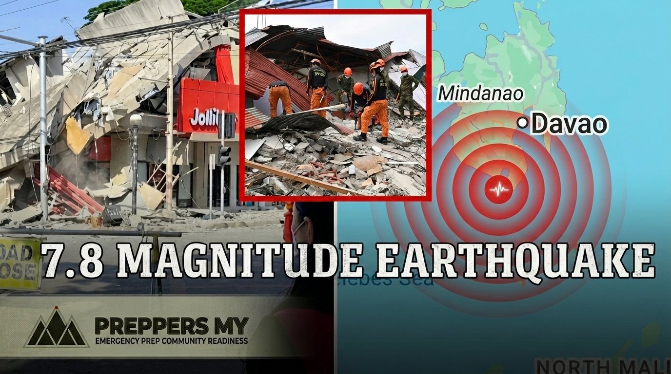
On the morning of June 8, 2026, one of the most powerful earthquakes to hit Southeast Asia in decades tore through the southern Philippines. The magnitude 7.8 quake struck offshore near the island of Mindanao, sending shockwaves through coastal cities, collapsing buildings, and triggering tsunami warnings across the region — including evacuation alerts for parts of Malaysia and Indonesia.
The death toll has climbed to at least 55 people, with dozens more still missing and thousands displaced from their homes. As rescue teams work through rubble and landslide-isolated villages, the scale of the destruction continues to emerge.
📋 Key Facts At A Glance
-
📍
LocationOffshore Sarangani, southern Mindanao, Philippines
-
📊
Magnitude7.8 (USGS) — one of the strongest in 50 years
-
⏰
Time7:40 AM local time, Monday June 8, 2026
-
🌊
Tsunami WavesUp to 1.4 m recorded along Mindanao’s southern coast
-
💀
DeathsAt least 55 confirmed, with 38+ still missing
-
🏥
InjuredOver 200 people, hospitals forced to evacuate
-
🏠
DisplacedThousands across landslide-isolated villages
-
🔔
AftershocksContinued for hours; largest measured 6.5
What Happened — A Minute-by-Minute Picture
Just before 7:40 in the morning, residents of General Santos City — a port city of 722,000 people — felt the ground shake violently for approximately 30 seconds. The quake originated offshore near the Sarangani province, at a depth of around 55 kilometres along the northern Sangihe Trench. Buildings swayed, walls cracked, and in some cases, entire structures came down.
Among the worst affected sites was St. Elizabeth Hospital, where sections of the building were severely damaged, forcing patients and medical staff to evacuate and operate temporarily in the open air. A Jollibee outlet in General Santos City collapsed entirely, with images of police officers gathered at the rubble circulating widely online.
The Philippine Institute of Volcanology and Seismology (PHIVOLCS) issued immediate tsunami warnings for Sarangani, Davao Occidental, Tawi-tawi, Sulu, Zamboanga, and Sultan Kudarat provinces. Tsunami waves of up to 1.4 metres were recorded along Mindanao’s southern coast between 7:42 AM and 8:45 AM. Smaller waves also reached Indonesia’s North Maluku province, and Japan’s Ogasawara Islands.
Malaysia Was On Alert Too
What many Malaysians may not realise is that the June 8 earthquake triggered evacuation warnings for coastal areas of Malaysia and Indonesia. Jakarta’s meteorological agency eventually lifted the alert, but the warning was real — and it was issued within minutes of the quake striking.
This is not a hypothetical. Malaysia sits at the edge of the Ring of Fire’s seismic influence. The 2004 Indian Ocean tsunami devastated parts of Penang and Kedah. Our coastal communities remain vulnerable to waves generated by quakes hundreds of kilometres away — and we may have as little as 30 to 60 minutes of warning.
Preparedness Saved Lives — This Time
Here is the headline that didn’t get enough attention: Philippine officials confirmed that years of disaster preparedness drills helped prevent a much larger casualty toll. In a country that sits squarely on the Ring of Fire, communities have trained for exactly this scenario — and that training showed.
People knew to move away from the coast. They knew not to re-enter damaged buildings. They knew where evacuation points were. That institutional muscle memory, built through repeated community drills, is what kept the death toll from being far worse given the earthquake’s intensity.
The rescue effort is ongoing. The mayor of a southern Philippine town pleaded for helicopters to deliver food to villages cut off by landslides. Relief operations are being backed by church groups and government agencies. But the families who had emergency kits, who had stored water, who had a plan — they are the ones not depending on those helicopters right now.
What This Means For Malaysian Families
Malaysia is not immune. We face our own slate of disasters — flash floods, prolonged power outages, haze, supply disruptions, and yes, the distant but real possibility of tsunami impact on our coasts. The Philippines earthquake is not a distant tragedy to scroll past. It is a rehearsal we didn’t attend, playing out in our backyard.
✅ Three Things You Can Do This Weekend
1. Build or review your 72-Hour Emergency Kit. Water, food, first aid, medication, torch, radio, important documents. If you haven’t done this yet, start this weekend. Our full checklist is free — link below.
2. Know your evacuation route. If you live near the coast, or in a flood-prone area, sit down with your family and agree on a meeting point and a route out. Don’t assume everyone knows. Say it out loud. Write it down.
3. Download an offline emergency guide. When the internet goes down — and in a real disaster, it will — you need information you can access without a signal. PreppersMY’s guides are downloadable and printable for exactly this reason.
Is Your Family’s 72-Hour Kit Ready?
Download our free checklist — built specifically for Malaysian families — and start building your emergency kit today. No fluff, no fear-mongering. Just practical steps.
Get the Free Checklist →